www.monumentaustralia.org
Home » Themes » Landscape » Settlement
Township of CooladdiPrint Page 
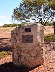
The cairn marks the site of the original township of Cooladdi, which was renamed in 1913 from its original name of Yarronvale.
View Google Map
Location
| Address: | Cooladdi Access Road, Cooladdi, 4479 |
|---|---|
| State: | QLD |
| Area: | AUS |
| GPS Coordinates: | Lat: -26.640803 Long: 145.463081 Note: GPS Coordinates are approximate. |
Details
Dedication
| Approx. Monument Dedication Date: |
|---|
Front Inscription
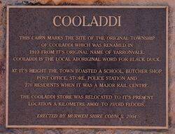
Cooladdi
This cairn marks the site of the original township of Cooladdi, which was renamed in 1913 from it`s original name of Yarronvale. Cooladdi is the local Aboriginal word for black duck.
At it`s height the town boasted a school, butcher shop, post office, store, polove station and 270 residents when it was a major rail centre.
The Cooladdi store was relocated to it`s present location a kilometre away to avoid floods.
Erected by Murweh Shire Council 2004
Left Side Inscription
Back Inscription
Right Side Inscription
Inscription in Proximity
Source: MAMonument details supplied by Monument Australia - www.monumentaustralia.org.au


